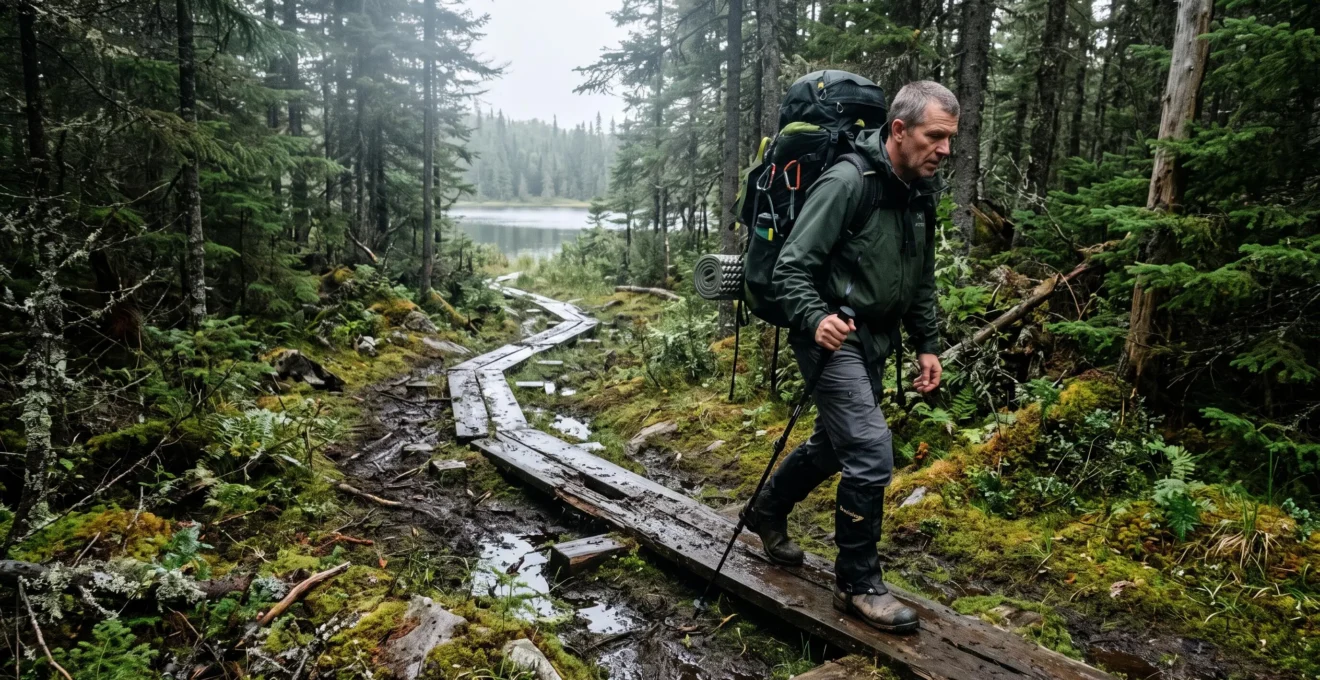
Canada’s boreal forest offers hiking experiences ranging from accessible boardwalks through wetlands to remote routes crossing spruce woodland, lakeshores and muskeg. These landscapes can feel welcoming near developed trailheads yet become demanding when muddy ground, limited communication and long distances from assistance enter the picture.
Exploring them safely starts with choosing a route that matches current conditions, not simply the distance shown on a map. Spring thaw can make established trails impassable, forest cover can complicate navigation, and apparently firm vegetation may conceal saturated soil. Wildlife encounters and rapidly changing weather introduce further considerations, particularly on overnight journeys.
Responsible hiking is equally important. Boreal mosses, lichens and wetland soils are vulnerable to repeated disturbance, while wildlife can suffer when visitors approach too closely or leave food unsecured. A carefully planned outing therefore protects both the people travelling through the forest and the ecosystems they have come to experience.
Boreal forest hiking essentials
- Choose trails using current conditions, seasonal access information and the group’s actual experience rather than distance alone.
- Prepare for unreliable cellular coverage with offline navigation, independent backups and a shared trip plan.
- Protect sensitive vegetation and wildlife by staying on established routes, minimizing disturbance and planning campsites carefully.
- Why Do Boreal Hiking Trails Become Difficult During Spring Thaw?
- How to Navigate Boreal Trails When Your Phone Has No Signal
- Boardwalk Trails or Remote Forest Routes: Which Suit Beginner Hikers?
- Trail Habits That Can Damage Mosses, Wetlands and Boreal Vegetation
- When Are Boreal Wildlife Viewing Conditions Most Favourable?
- Why Can Mountain Weather Become Dangerous Even During Summer Camping Trips?
- Planning Mistakes That Can Disrupt Trips to Remote Canadian Destinations
- How to Plan a Safe Backcountry Camping Trip in Canada’s Mountain Regions
Why Do Boreal Hiking Trails Become Difficult During Spring Thaw?
Boreal hiking trails become difficult during spring thaw because melting snow and incompletely thawed ground create saturated, unstable surfaces. Water can accumulate above frozen soil, softening trail beds, weakening boardwalk foundations and increasing erosion. Conditions vary considerably by latitude, elevation and local drainage, so a route manageable in midsummer may be unsuitable several weeks earlier.
Much of Canada’s boreal landscape includes low-lying wetlands, organic soils and poorly drained terrain. During freeze-thaw transitions, surface ice may melt before deeper layers can absorb or transmit water efficiently. Muskeg can become exceptionally soft, while repeated freezing and thawing may destabilize exposed soil or trail infrastructure.
Boardwalks help visitors cross wet areas without walking directly on vegetation, but seasonal movement, flooding and deteriorating supports can leave individual sections tilted, submerged or unsafe. Never assume that a developed trail remains usable simply because its entrance is accessible.
Instead of following a fixed spring hiking calendar, evaluate the conditions that determine whether a particular route is ready.
| Factor | What to investigate | Planning implication |
|---|---|---|
| Latitude | Local snowmelt and ground-thaw progress | Northern trails may remain affected by seasonal snow or saturated ground after southern routes improve. |
| Elevation | Snow remaining at higher points | Approach trails and elevated sections may have different conditions. |
| Snowline retreat | Remaining snow cover and runoff | Exposed ground does not necessarily mean dry or stable footing. |
| Trail status | Park reports, closures and boardwalk notices | Official restrictions and recent inspections take precedence over anticipated seasonal patterns. |
Walking around mud or damaged boardwalks may seem safer, but repeated detours widen trail corridors and crush adjacent mosses and lichens. When the designated route cannot be crossed safely without leaving it, turning back is generally the better decision.
Consider lower-elevation or more southerly trails with confirmed access, established hard-surface routes, or short maintained loops. Contact the relevant provincial park operator or local trail association when published reports do not adequately describe conditions.
Once trail conditions are suitable, the next challenge is remaining oriented in forest terrain where familiar navigation cues and mobile connectivity may disappear.
How to Navigate Boreal Trails When Your Phone Has No Signal
Navigating boreal trails without cellular service requires several independent navigation methods. Download suitable offline maps before departure, carry a route or GPX track where appropriate, and bring a paper topographic map and compass that you know how to use. Combine these tools with regular position checks, identifiable checkpoints and an itinerary shared with a trusted contact.
Cellular reception and satellite positioning are different systems. A smartphone may still calculate its location without mobile coverage, provided its satellite receiver functions and the necessary mapping data are stored locally. However, electronic positioning is not infallible: canopy, terrain and poor satellite visibility can reduce accuracy, while wet weather, cold batteries or equipment damage can make devices unusable.
Dense boreal forest also complicates visual orientation. Similar-looking lakes, wetland margins and spruce stands can be mistaken for one another. A cut block or forestry track may provide a temporary landmark, but it should not be treated as a reliable substitute for a verified route.
A practical navigation routine divides the intended route into identifiable sections. Before leaving each checkpoint, identify the next feature, estimate the expected travel direction and distance, and confirm that the terrain matches the map. Record progress at junctions, stream crossings and other meaningful landmarks.
If observations begin to contradict the planned route, stop and establish the last confidently known position rather than continuing on an assumption. Navigation uncertainty becomes more dangerous when hikers try to recover lost time by moving faster.
According to Parks Canada‘s hiking preparation recommendations, limited cellular service makes exclusive reliance on a phone’s GPS inadvisable. The agency recommends appropriate navigation equipment and checking trail conditions before hiking.
Pre-trip communication provides another safety layer. AdventureSmart‘s Canadian outdoor trip-planning guidance recommends leaving route details, equipment information and an anticipated return time with a responsible person. Agree on when that person should seek assistance if there is no contact.
Before departure, identify the destination’s emergency procedures and which local authority should be contacted. Search-and-rescue arrangements may differ among national parks, provincial parks, conservation reserves and other public lands. A satellite communicator or personal locator beacon can strengthen emergency preparedness, but it does not replace navigation competence.
This level of preparation is particularly important when deciding whether a beginner should remain on an established trail network or attempt a remote route.
Boardwalk Trails or Remote Forest Routes: Which Suit Beginner Hikers?
Boardwalk trails and well-marked frontcountry routes generally suit beginner hikers better than remote boreal routes. Their defined walking surfaces, easier navigation and more accessible exit options reduce the consequences of fatigue or changing weather. Remote routes demand stronger navigation, terrain assessment and emergency preparation, even when their advertised distances appear short.
The relevant distinction is not simply walking distance. A maintained boardwalk may allow visitors to observe wetland ecosystems without navigating saturated muskeg, while a short unmarked route can involve uncertain crossings, difficult footing and limited rescue access.
There is also an important middle option: established hiking loops in boreal parks with maintained junctions, marked routes and nearby access roads. These give developing hikers opportunities to practise pacing, navigation and weather decisions without immediately committing to isolated terrain.
| Decision factor | Boardwalk or maintained frontcountry trail | Remote forest route |
|---|---|---|
| Navigation | Generally clearer routes and established junctions | May require independent route-finding |
| Trail variability | Often managed, although damage and closures remain possible | May involve changing ground, water crossings or unclear tread |
| Exit options | Often closer to a trailhead or access road | May require substantial travel to reach assistance |
| Weather or fatigue | More opportunities to shorten an outing | Greater consequences if progress slows |
| Suitable preparation | Basic hiking equipment and route awareness | Independent navigation, emergency planning and self-reliance |
Beginners can assess their readiness by considering whether everyone in the group has completed comparable distances, understands the planned terrain and can navigate if signs disappear. Group members with children, limited outdoor experience or differing physical abilities may benefit from a shorter maintained route.
Parks Canada identifies an average beginner pace of approximately 2 to 2.5 km per hour on a nature trail. That figure is a general planning reference, not a reliable prediction for wet muskeg, rough terrain or extended water crossings.
A short route is not automatically an easy route. A remote kilometre involving unstable ground and uncertain navigation can demand more skill than several kilometres of accessible boardwalk.
Progress toward remote hiking by successfully completing maintained loops under varied but manageable conditions, demonstrating reliable map-and-compass skills and becoming comfortable making conservative turnaround decisions.
Whichever route is chosen, hikers still need to understand how their movement affects the vegetation immediately beside and beneath the trail.
Trail Habits That Can Damage Mosses, Wetlands and Boreal Vegetation
Boreal vegetation is vulnerable to damage when hikers leave established trails, crush mosses and lichens, compact saturated ground or create informal campsites. Recovery can be slow, especially where soils are thin, temperatures limit growth and repeated foot traffic prevents vegetation from re-establishing. Staying on designated surfaces and minimizing ground disturbance are fundamental responsible-hiking practices.
Mosses, lichens and liverworts form an important part of the boreal forest floor. These organisms help structure surface habitats and interact with soil moisture and nutrient processes. Their response to disturbance varies by species and site, but some damaged ground-cover communities can take decades to recover.
Wet soils introduce an additional problem. Footsteps may displace organic material, create depressions and redirect surface water. When many visitors bypass the same muddy section, the trail can expand into an increasingly wide disturbed corridor.
On established trails, walk on the designated tread where it remains safe and open. Avoid creating parallel tracks around wet sections. If passage requires damaging undisturbed vegetation or crossing unsafe infrastructure, turn around or choose another route.
In areas where off-trail travel is permitted, the appropriate approach depends on surface durability and local guidance. Small groups may disperse movement across robust terrain rather than repeatedly creating a new single track, but fragile moss, lichen, wetland and alpine surfaces should be avoided rather than crossed indiscriminately.
Camping creates concentrated pressure on the ground. Use designated campsites where provided, select durable surfaces where dispersed camping is permitted, and avoid fragile lichen mats, wetland edges and visibly undisturbed vegetation.
Fallen wood is part of the forest ecosystem, providing habitat and participating in decomposition and nutrient cycling. Collecting it around heavily used campsites or sensitive shorelines can increase local disturbance. Use established cooking equipment where appropriate and comply with current fire bans and destination-specific rules.
The same principle applies to waste. Pack out litter and food scraps. Follow local requirements for human waste because shallow soils, high water tables and sensitive watercourses may make ordinary burial practices unsuitable.
BC Parks‘ official backcountry guide provides practical guidance on low-impact travel, food storage, campsite selection and environmental protection. Its recommendations should be interpreted in the context of the destination’s own regulations and ecological conditions.
Minimizing disturbance also supports better wildlife experiences: animals are more likely to behave naturally when visitors avoid approaching, feeding or repeatedly interrupting them.
When Are Boreal Wildlife Viewing Conditions Most Favourable?
Boreal wildlife viewing can be particularly rewarding around dawn and dusk, when many mammals are active, and near habitat features that provide food, water or shelter. However, activity varies by species, season and local conditions. Observing from established trails or designated viewpoints is generally safer and less disruptive than approaching animals or following them into sensitive habitat.
Instead of relying on a fixed wildlife calendar, learn to identify promising habitat. Shorelines, beaver ponds, wetland edges and transitions between forest and open areas may provide opportunities to observe birds and mammals. Recent tracks or scat can indicate animal activity, although neither guarantees a sighting.
Regenerating areas following natural disturbances such as wildfire may also attract some species because vegetation composition and food availability change during recovery. Access restrictions and local safety conditions must always be respected.
Seasonal behaviour matters. Spring and early summer may coincide with births and the presence of vulnerable young, while mating periods can increase territorial or defensive responses in certain species. An apparently quiet animal should never be assumed to be comfortable with human proximity.
Parks Canada’s general hiking guidance recommends maintaining at least 100 metres from bears, bison, cougars and wolves and 30 metres from other large animals, including moose and elk. Destination-specific requirements and conditions may call for greater distances.
100 metres
Parks Canada’s general minimum viewing distance recommendation for bears, bison, cougars and wolves. This is not a guarantee of safety and does not override park-specific requirements.
Parks Canada, How to prepare for a hike.
Food and scented items should be stored according to the applicable park’s wildlife-safety requirements. Never feed wildlife, leave food unattended or approach an animal for a closer photograph.
When encountering a bear, remain calm, avoid approaching and follow the current bear-safety instructions for that destination and species. Carry bear spray where recommended and permitted, and know how to use it. When encountering a moose, maintain distance, avoid blocking its escape route and retreat if it shows agitation. Never position yourself between an adult and its young.
Repeated close approaches or feeding can encourage wildlife to associate people with food or tolerate unsafe proximity. Such habituation and food-conditioning can increase conflict and sometimes lead to management interventions or animal deaths.
Responsible wildlife viewing prioritizes the animal’s behaviour over obtaining a photograph. Binoculars and patience provide better options than reducing the distance.
Because wildlife observations often take hikers farther from trailheads or keep them outdoors near changing evening conditions, weather awareness becomes an essential part of planning.
Why Can Mountain Weather Become Dangerous Even During Summer Camping Trips?
Mountain weather can become dangerous during summer because elevation, exposed terrain and rapidly developing weather systems can produce cold temperatures, heavy rain, thunderstorms or even snow despite warm conditions at lower elevations. Hikers travelling through mountain-adjacent boreal landscapes must prepare for abrupt changes, especially when wet clothing, wind and delayed evacuation increase the risk of hypothermia.
In western and northern Canada, some hiking itineraries combine forested valleys with higher mountain terrain. Conditions at the trailhead may differ substantially from those at an exposed pass or campsite.
Elevation generally influences temperature, while ridges, valleys and terrain orientation affect wind exposure and local weather. Cold air may collect in sheltered valleys overnight, and storms can reduce visibility while making river crossings or exposed routes more hazardous.
Summer warmth can create misplaced confidence. Lightweight clothing may be adequate during a sunny approach but insufficient after sustained rain, wind or an unexpected overnight stop. Hypothermia is possible above freezing when people become wet, cold and unable to maintain body heat.
Banff National Park‘s backcountry guidance illustrates the importance of local conditions: higher-elevation routes may remain snowbound into late June, and stream flows can be especially high during June and July. These observations apply to Banff’s mountain environment and should not be treated as a universal boreal hiking timetable.
Weather decisions should be built into the itinerary rather than improvised after conditions deteriorate.
- Check the forecast relevant to the actual terrain and elevation, including any applicable alpine, regional or marine forecast for exposed coastal areas.
- Look for indications of changing conditions, such as developing storm clouds, increasing wind, falling temperature or deteriorating visibility.
- Identify conservative turnaround points before departure and reassess conditions at exposed sections or difficult crossings.
- Carry insulation, waterproof layers and emergency shelter appropriate to the route, regardless of the initial temperature.
Recognizing a storm does not require predicting its exact arrival. If thunder is audible, move away from exposed ridges and other hazardous locations when safe to do so, following established lightning-safety guidance.
In remote boreal terrain, weather delays can compound other risks. A flooded crossing may force an extended wait, while an attempt to bypass it may create navigation uncertainty. Food reserves, daylight and battery capacity can all become more limited as a result.
Early decisions usually preserve more safe options than last-minute route changes. Remaining on a known route or returning to a safer location can be preferable to attempting an unfamiliar detour.
Weather preparation is most effective when integrated into the wider logistical plan, particularly for destinations where roads, supplies and communication services are limited.
Planning Mistakes That Can Disrupt Trips to Remote Canadian Destinations
Remote Canadian hiking trips are often disrupted by underestimated travel times, unreliable access assumptions, missing permits and inadequate emergency margins. Sparse services and seasonal road conditions can turn a minor delay into an overnight exposure problem. A dependable itinerary therefore verifies transportation, access, supplies, communication and alternative exit options before the group leaves.
Distances on a road map rarely tell the full story of northern travel. Gravel surfaces, road maintenance, seasonal closures and limited services may affect driving and shuttle arrangements. Fuel, food, accommodation and cellular reception should be verified rather than assumed to exist at the next settlement or junction.
Access planning involves more than checking whether a trail appears on a map. Parks may require reservations or backcountry permits, restrict certain routes, close facilities or impose fire bans. Travel on Indigenous lands or through areas subject to specific land-use arrangements requires attention to applicable permissions, local guidance and cultural considerations.
A useful way to test an itinerary is to ask what happens if one critical step fails.
Hypothetical example: a missed remote shuttle
A hiking group plans to finish a remote forest route shortly before its arranged pickup. Saturated trail conditions slow progress, and the group reaches the trailhead after the vehicle has departed. There is no cellular reception, and the next confirmed transport option is unavailable until the following day.
If the group has an agreed missed-pickup procedure, appropriate overnight equipment and a trusted contact holding its itinerary, the situation is more manageable. Without those safeguards, an otherwise ordinary delay may become an emergency. This is a planning illustration, not a documented rescue incident.
Build sufficient margins into the itinerary by allowing for slower travel, access changes and weather interruptions. On longer remote journeys, supplementary food and equipment may be necessary. Parks Canada’s Banff backcountry guidance recommends carrying supplies for at least one additional day in its park-specific context.
Identify primary and alternate exits, including any crossings or roads that might become inaccessible. Confirm whether an alternate route is genuinely usable without violating closures or entering land requiring additional authorization.
Provide a trusted contact with the route, intended campsites, transport arrangements, equipment information and expected return. Agree on a response procedure and appropriate emergency contacts for the jurisdiction. A satellite messenger can provide an additional communication option, but coverage, battery condition and operational limitations must be understood beforehand.
With transport, access and emergency contingencies established, the final preparation step is to turn those decisions into a coherent backcountry camping plan.
Key takeaways before planning an overnight trip
- Choose the route according to the weakest relevant capability in the group, not the ambitions of its most experienced member.
- Verify that camping, access and wildlife-food storage arrangements are appropriate to the specific destination.
- Prepare for safe self-management when assistance may be delayed, including the possibility of an unplanned overnight stay.
How to Plan a Safe Backcountry Camping Trip in Canada’s Mountain Regions
A safe backcountry camping trip in Canada’s mountain regions begins with a realistic route, confirmed access and equipment matched to weather, navigation, injury and wildlife risks. Where mountain routes pass through boreal or northern forest environments, additional attention is needed for saturated terrain, sensitive campsites and limited services. Emergency communication supports the plan, but independent preparation remains essential.
First, define the route using actual experience, expected trail conditions and the capabilities of every participant. Calculate travel time conservatively and include allowances for water crossings, rest stops, elevation changes and uncertain footing. Confirm permits, campsite availability and current access restrictions before finalizing transportation.
Choose equipment according to the consequences of delays rather than the most favourable forecast. Waterproof clothing, suitable insulation, emergency shelter, lighting, navigation backups and water-treatment equipment become especially important when a safe exit cannot be reached quickly.
Camping introduces additional responsibilities. Select designated sites where required and otherwise use permitted, durable surfaces. Avoid drainage channels, exposed hazard areas, wildlife travel corridors and fragile vegetation. Keep sufficient separation from water and trails as required by the destination. For example, BC Parks provides guidance recommending a minimum campsite separation of 30 metres from water and trails in its relevant outdoor-ethics context; local rules may differ.
Store food and scented items using the approved methods for the destination, which may involve provided storage infrastructure, suitable bear-resistant containers or another expressly permitted method. Bear hangs should not be assumed acceptable or effective everywhere. Treat water from natural sources even when it appears clear.
Backcountry groups must also consider how long an evacuation could take. A basic first-aid kit and the knowledge to use it are important, but some routes warrant more advanced first-aid preparation, additional insulation and a reliable emergency communication device. In remote environments, help may be hours or longer away.
Five checks to complete before a boreal backcountry departure
- Confirm the route. Save a route map showing the trailhead, intended campsites, significant crossings and planned exits.
- Verify permissions and conditions. Prepare a record of applicable permits, campsite bookings, trail reports, closures and fire restrictions.
- Test essential equipment. Complete an equipment check covering navigation, weather protection, food storage, water treatment and emergency shelter.
- Document the emergency plan. Record the agreed response to injury, separation, navigation failure or missed transportation, including available emergency contacts.
- Share the itinerary. Give a trusted person the route, group details, anticipated return and agreed overdue-response instructions, and confirm receipt.
Group size should remain compatible with local limits and the capacity of available campsites. Large parties may concentrate pressure on vegetation and complicate movement through narrow or wet routes. Where camping is permitted outside developed sites, choose locations that avoid unnecessary new impacts.
Fires, food scraps and emergency detours can leave lasting marks when visitors are inadequately prepared. Cooking with appropriate equipment, carrying sufficient supplies and selecting feasible daily distances reduce the likelihood of improvised decisions that disturb additional ground.
A successful backcountry plan should also have a clear cancellation threshold. Unsafe water levels, unresolved access restrictions, severe weather or inadequate navigation capability are valid reasons to postpone the trip. Turning back before a problem develops is a successful safety decision, not a failed expedition.
For the next outing, select a manageable trail, check its latest conditions with the responsible park or trail authority, share a detailed trip plan and commit to travelling only where access and conditions allow. A rewarding boreal experience is one that leaves both hikers and the surrounding landscape in good condition.
Do I need a satellite communicator for every boreal forest hike?
Not every short, maintained trail requires the same emergency equipment as an isolated backcountry route. However, cellular coverage should never be assumed. For remote or overnight trips, a satellite communicator or personal locator beacon is an important safety option to evaluate. Carry suitable navigation backups and share an itinerary regardless of whether electronic emergency messaging is available.
Can I hike on a boreal trail if it is muddy but officially open?
An open trail is not necessarily dry, and conditions can change after the latest inspection. If the designated tread remains safe and passable, follow local guidance and stay within the established corridor. Do not create detours through sensitive vegetation. Turn back when damaged structures, deep water or unstable ground make responsible passage impractical.
Are dogs permitted on Canadian boreal hiking trails?
Dog access depends on the park, protected area and individual trail. Some destinations permit dogs subject to leash requirements, while others restrict them to protect wildlife or visitors. Check destination-specific rules before travelling, keep pets under the required control and prevent them from disturbing animals or sensitive vegetation.
Is water from remote boreal lakes and streams safe to drink untreated?
Clear-looking water is not proof of safety. Remote lakes and streams can contain microorganisms capable of causing illness. Carry a suitable water-treatment system, understand its limitations and follow the destination’s recommendations. Plan enough water capacity for stretches where reliable sources may be unavailable or difficult to access.
How can I tell whether a remote hiking route is too difficult for my group?
Compare the route’s navigation demands, surface conditions, crossings, duration and distance from assistance with the experience of every participant. Difficulty is not determined by length alone. If the group cannot confidently manage a navigation error, weather delay or unexpected overnight stay, choose a maintained route with simpler exit options or develop the necessary skills before attempting the remote itinerary.